News
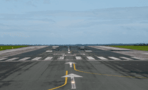
Tough landing conditions for aircraft at Pietermaritzburg Airport
The aviation regulator has increased the landing altitude from 500 to 820 feet.
Bad weather and poor visibility makes landing difficult at Pietermaritzburg Airport due to a higher minimum descent altitude requirement; that’s why pilots have to sometimes avoid landing in such conditions and divert to other airports.
The aviation regulator has increased the landing altitude from 500 to 820 feet.
A traveller contacted The Witness recently after their Airlink flight was redirected to Durban as the flight could not land due to bad weather conditions.
Msunduzi Municipality dispelled rumours that the air-ground equipment had experienced problems, confirming that in fact the equipment “was working optimally”.
Msunduzi spokesperson Ntobeko Mkhize said with inclement weather, the cloud base will be much lower and the visibility will decrease.
Should an aircraft reach the prescribed MDH and still not have the runway in sight then they cannot land as per the prescribed compliance and safety requirements. In days of severe weather and where the cloud base is lower than the MDH go-arounds and diversions are to be expected,” said Mkhize.
She said Pietermaritzburg was known for its high terrain, which has a slightly greater bearing on the MDH.
Airport management and Airlink are working closely with the regulatory authority to revise the MDH, she said. Airlink said the change in landing altitude was a challenge for the company and the situation worsened during bad weather conditions.
Linden Birns, company publicist and media relations advisor, said the United Nations International Civil Aviation Organisation (Icao) sets the global standards and recommended practices for civil aviation.
He said Icao periodically audits civil aviation authorities and civil aviation infrastructure service providers such as air navigation services (in SA, this is the Air Traffic Navigation Services (ATNS).
“Each country is then required to establish a civil aviation authority that formalises Icao’s standards and practices in the form of civil aviation regulations and legislation, which it then enforces. An air navigation service is responsible for designing the airspace surrounding and above airports and the routes between them.
“An obstacle clearance height means the pilots must have established visual contact with
the runway by the time the descending aircraft reaches that altitude. If theycannot see the runway at that point then they must abandon the approach and either climb and try again or divert the flight to another airport,” said Birns.
He said a few weeks ago the ATNS raised the obstacle clearance height by around 500 feet to 820 feet, even though no new obstacles have been erected under the flight path.
“It had been perfectly safe for Airlink’s aircraft, which are equipped with the latest radio and satellite navigation equipment, and its pilots are trained and licensed to operate them. The discussions are ongoing,” he said.
He said the airline was “painfully” aware of the frustration this was causing its customers and the impact on its track record as South Africa’s most reliable on-time airline and apologised for any inconvenience caused.
In instances where a flight is unable to land at Pietermaritzburg, the pilots will probably divert the flight to Durban where the aircraft would be refueled and wait for conditions to improve before flying to Pietermaritzburg to make another attempt to land. He said if the conditions were still not suitable, the flight would return to Johannesburg.
“Passengers who want to leave the flight in Durban are free to do so but will have to make their own way to Pietermaritzburg. Should the flight need to return to Johannesburg, the passengers onboard will be rebooked onto the next flight or may apply for a refund,” he said